This write-up is a light technical description of the maps I had generated at home-office several months before we arrived here. We always prepare ourselves with the latest map data available, acquire all the State, Federal and topographic data layers, and assemble them well in advance of any of our expeditions. In the case of this Chaco expedition, we wanted to explore (remotely) the entire region's hypsographic (elevation data) and ecological information to get a feel for the Chaco region and the ancient civilization's altitude and position within it.
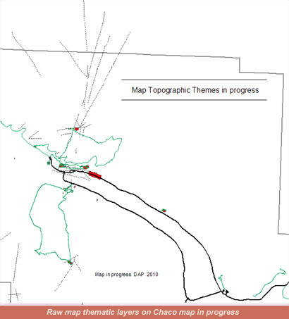
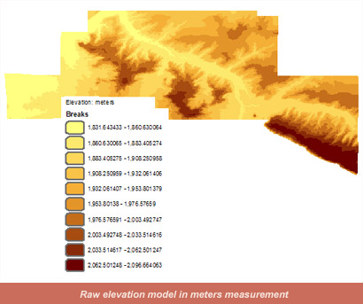
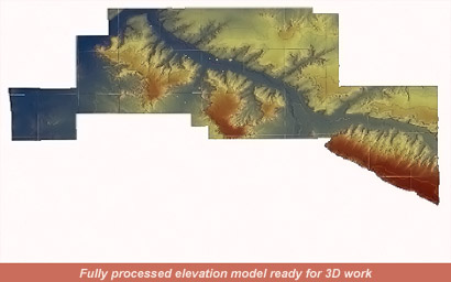
To do this, I wanted to generate my own topographic elevation vector lines using the latest iteration of the National Elevation Dataset terrain models at the best resolution possible: 10-meters. I downloaded all the quadrangles I needed to comprise the area not only encompassed by the Chaco Culture National Historical Park, but also the areas between the Chaco ruins outlier sites, and the terrain surrounding our long road to the Park site itself. I used powerful GIS software to tile the myriad quads together into a contiguous dataset with seamless overlap, then finely gridded the 10-meter resolution digital elevation model to a 7-meter resolution model, and generated a visual hill-shaded terrain image to overlay on top of the real digital elevation model. Making the hill-shaded layer semi-transparent, I could create the effect of the mesas in 3D for visual effect, retaining the real elevation data set under it so I could sample elevations, and run complex analysis on the terrain data using other criteria (like simulate rainfall and where the most likely wash-outs may happen, where ancient Puebloans would most likely build dams and catchments for water collection, etc).
With my elevation data map done, we then acquired the latest NAIP (high-resolution National Agricultural Imagery Program) imagery at 0.99-meter resolution in 3 color bands: red, green, blue. I then acquired georeferenced electronic format topographic maps corresponding to the areas of the Chaco Canyon that we were interested in doing our investigation on (ancient Chacoan roads system emanating from Pueblo Bonito, and looking for (photo-interpreting) ruin sites less documented or altogether undocumented); these cryptic indicators on the digital topographics were heads-up digitized to a new geographical layer called: semi-documented sites. With this done, I deleted the digital topographic map from my GIS system, turned on the new semi-documented sites layer, made that layer 50 percent transparent, and using the high-resolution 3-band NAIP imagery underneath, heads-up digitized the prominent archaeological features I could interpret from the NAIP imagery. Then, exporting the new undocumented sites project with underlying NAIP image as a GeoTIFF with world geographic reference file, I converted this GeoTIFF into a file that our GPS could read (in NAD83 UTM Zone 13, coordinate system).
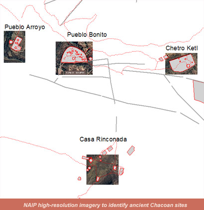
The resultant custom GPS layer was used to navigate to my actual on-the-ground digitized photo-interpreted sites so we could see first-hand the locations. Because the Chaco Culture National Historical Park has sectors that are completely off limits to visitors (and, in some cases researchers), we had to limit our look-see to areas that were open to the public. Additionally, because doing anything but looking and photographing the sites here is possible, we simply observed and photographed.
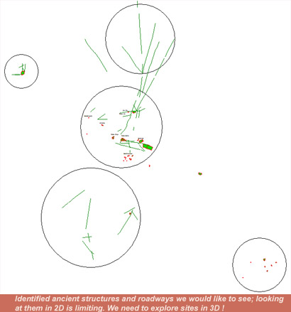
Observing a 2-dimensional map rendering of the ancient roadways and structures is limiting; we need to see how the ancient roadways relate to the Anasazi structures in terms of long-distance observing, directional marking and spatial orientation relationship with ancient buildings.
We then generated a 3D analysis of the entire Chaco region and extruded the potential sites we had digitized by an arbitrary height of to 20 feet (well, perhaps not so arbitrarily!), and exported a real geographically-correct terrain model that we could fly over virtually-- similar to using a helicopter.

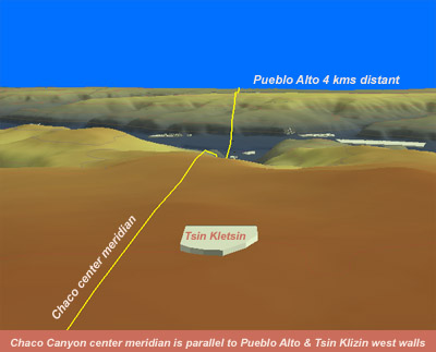
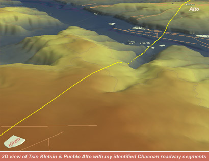
We could study sun angles on the ancient buildings from a perspective of any time of the year present or past correctly, and also obtain a view from the top of any structure looking out at any bearing we desired (try attempting to stand on top of Pueblo Bonito's highest structure for a birds-eye view; you'd quickly become persona non grata!). This enables us to visualize virtually what the ancient Anasazi builders may have been shooting for when they constructed their Great Houses and observatories over 800 to 1000 years ago. Additionally, being fascinated by what are called ancient Chacoan roadway systems, the same methodology was used to remotely identify the most obvious roadways by studying the National Parks generalized ancient roadways paper maps, and then using air photo features identification techniques, heads-up digitizing geospatially correct ancient roadway features I interpreted from the remote-sensed data and outputting a geographically referenced GPS file for us to refer to out in the field. In effect, we could formulate and test exploratory hypotheses on ancient structural orientation to cardinal points, and architecture and ancient roads orientations, etc, without ever setting foot in the Chaco Cultural National Historic Park in vivo.


Now, back to the Chaco Expedition story here.
-THE END-